
Northern Canada Vessel Traffic Services Zone (NORDREG)
Advance Reporting Requirements
This page will provide vessel masters with information related to completing the new NORDREG report form. NORDREG reporting regulations have not changed.
On this page
NORDREG Zone Reporting
To obtain clearance into northern Canadian waters, the master of the ship must report to NORDREG Canada or to the nearest Canadian Coast Guard (CCG) MCTS Centre, as per the Radio Aids to Marine Navigation (RAMN) 2023, section 3.8.3.
These reports are submitted by email to IQANORDREG@INNAV.GC.CA
New Electronic Form
Mariners are advised that all requests for vessel clearances into northern Canadian waters must be submitted to NORDREG Canada using the new electronic form available on the Canadian Coast Guard’s e-Navigation portal at: 3.8.3, will be entered in multiple tabs. This new form can be downloaded from the e-Navigation portal at:
https://e-navigation.canada.ca/topics/traffic/cvms/nordreg-en
The new NORDREG report form is a Microsoft Excel based document where required information, as per RAMN section 3.8.3, will be entered in multiple tabs.
Vessels are requested to attach the completed Excel report to an email when submitting NORDREG clearance requests prior to entering the zone (RAMN 3.8.3.2). Please confirm that the newest version of the form has been completed prior to submission. NORDREG reports submitted in an old format or an incorrect version of the new form will be returned and the vessel will be asked to resubmit in the new format and/or newest version.
Note –This Excel form should never be saved as or converted to a PDF, image, or any other file type. It must only be saved in an Excel (.xlsx) format.
Information related to this change is available in RAMN, Part 3: Vessel Traffic Services
Additional information related to the new NORDREG report form is available from Iqaluit MCTS (mid-May to mid-December) or Les Escoumins MCTS (mid-December to mid-May) upon request.
Form at a glance
The following pages display each of the form’s tabs and provides detailed information on how to complete the electronic form, in accordance with RAMN Section 3.8.3.
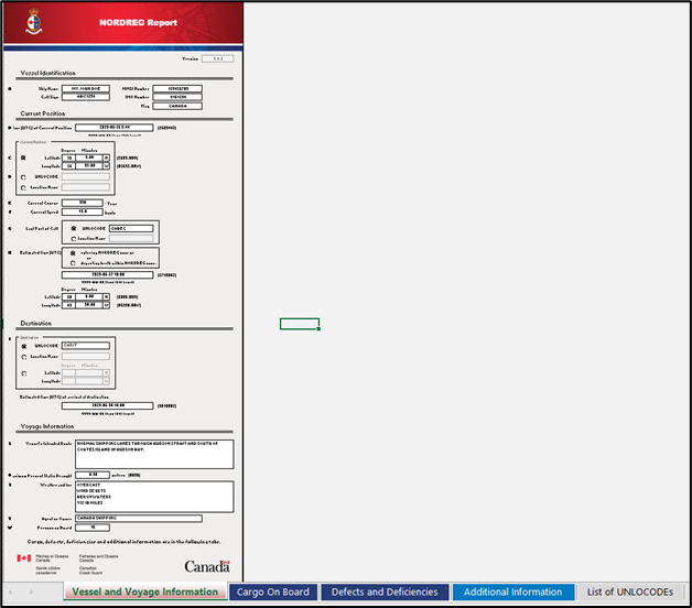
Vessel and Voyage Information
Prior to entering vessel information, it is important to verify the version of the form, located at the top of the report.
Users should ensure that the newest version of the form is downloaded prior to submitting the report. This information can be accessed at: https://e-navigation.canada.ca/topics/traffic/cvms/nordreg-en
Note: In this example, the current version of the report is 1.4.3. It is important to note that any report version 1.4.X will be accepted. However, if the newest version is 1.5.1, NORDREG Canada will not be able to accept any report version 1.4.X or lower.
Vessels may download the latest copy of the report from the above link, or obtain it from their agents.
After verifying the Version, the first tab of the report contains vessel and voyage information, which is divided into 3 sections:
-Vessel
Identification;
-Current
Position; and,
-Destination
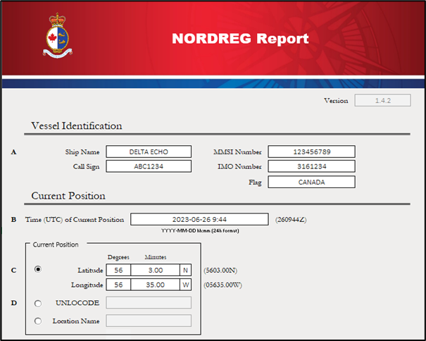
Vessel Identification
This section (A) provides fields to capture the Ship Name, Call Sign, MMSI, IMO number and Flag .
Note: The form may not allow direct copy and paste of information into the fields; however, information can be copied and pasted into the Excel formula bar.
Current Position

Date and Time of Current Position (B) must be entered in the following format:
YYYY-MM-DD hh:mm (24 hour format)
Current Position (C or D) – This section allows vessels to choose one (1) of three (3) position options:
1)Latitude/Longitude Position using Degrees and decimal
minutes,
2)UNLOCODE, or
3)Location Name (geographical name)
UNLOCODE is a five-character code system used to identify all named geographic places related to international trade. UNLOCODEs are used by most major shipping companies and the manufacturing industry around the world.
Note: When completing this form, the use of UNLOCODEs, where applicable, is preferred to ensure accuracy with MCTS’ vessel voyage management system.
More information about UNLOCODEs can be found here:
https://unece.org/trade/cefact/unlocode-code-list-country-and-territoryCourse, Speed, and Last Port of Call are to be entered into fields E-G.
Estimated Time of Entry or Exit of the NORDREG zone (H) – a vessel must select whether they are entering or exiting the NORDREG zone and provide the date and time of entry or exit, which must be entered in the following format:
YYYY-MM-DD hh:mm (24 hour format)
The vessel must also provide the latitude and longitude of the entry or exit position.
DESTINATION
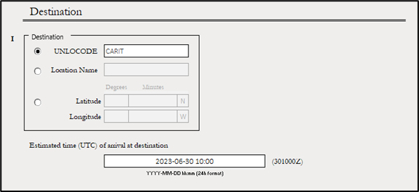
Destination (I) - This section allows vessels to choose one (1) of three (3) position options:
1)UNLOCODE,
2)Location Name (geographical name), or
3)Latitude/Longitude Position using Degrees and decimal minutes
The vessel’s Estimated time of arrival at the NORDREG Zone (I) must be entered in the following format:
YYYY-MM-DD hh:mm (24 hour format)
Note: A List of UNLOCODEs, located on tab 5 of the report, also includes a quick reference to Canadian and US locations.
VOYAGE INFORMATION
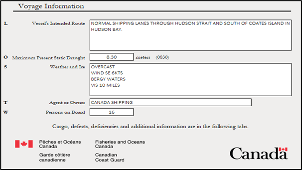
Vessel’s Intended Route (L) - the vessel must provide a brief description of the intended route through the NORDREG zone.
The Maximum Present Static Draught of the Ship (O) is to be provided in meters and centimeters (entered as a decimal).
Weather and Ice (S) – a brief description of the prevailing weather and ice conditions are to be entered into this field.
Note: In a free text field, such as S, press ALT + ENTER to start a new line in the same cell.
Agent or Owner (T) and Persons on Board (W) information should be entered, as per requirements in RAMN section 3.8.3.
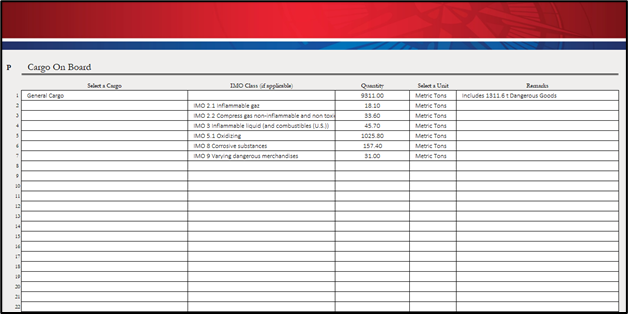
Dangerous Goods on Board
This tab gathers information pertaining to Cargo on Board, in accordance with item P in RAMN, section 3.8.3.
Defects and Deficiencies
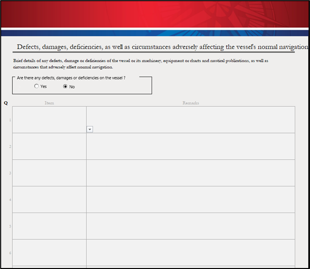
Defects, damage and deficiencies, as well as circumstances adversely affecting the vessel's normal navigation (Q)
Vessels are to provide brief details of any defects, damage or deficiencies of the vessel or its machinery, equipment or charts and nautical publications, or circumstances that adversely affect normal navigation.
If there are defects, damages or deficiencies to report, select “Yes” and include them in the report by using the “Item” drop-down menu along with remarks.
If there are no defects, damages or deficiencies to report, select the “No” option.
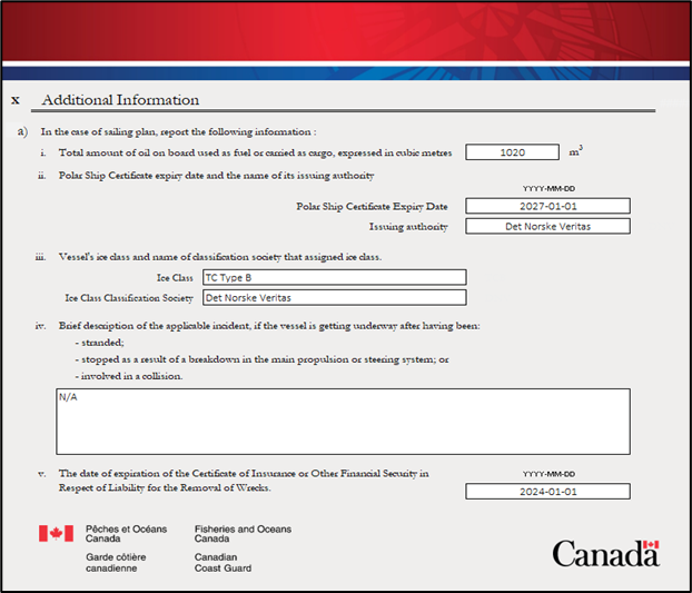
Additional Information
This tab gathers Additional Information required for a sailing report plan, in accordance with item X in RAMN, section 3.8.3.
List of UNLOCODEs

The vessel may refer to UNLOCODE tabs for information related to destinations or locations in Canadian waters or in the United States. Some common United States last port of call locations have also been included.
Using the UNLOCODE may reduce misspelled location names, using the wrong location with a similar name, or using a location of the same name but in a different province or territory.
More UNLOCODEs can be found online at:
https://unece.org/trade/cefact/unlocode-code-list-country-and-territory
Report a problem on this page
- Date modified: