St. Lawrence Waterways Channel Bottom Conditions
Instructions: Map Navigation
Keyboard users: To navigate the map with a keyboard, first click on the map to select it. Use the arrow keys to pan the map left or right, up or down. Use the plus (+) key to zoom in, and the minus (-) key to zoom out. Click the globe icon to zoom the map to its default setting.
Legend
- Water
- Natural deep water
- Bridges
 Harbor limits
 Power lines
- ↑
- - 0.1 m
- - 0.0 m
- - 0.1 m
- - 0.2 m
- - 0.3 m
- ↓
Text description of the map of the St. Lawrence waterways channel bottom conditions.
As the manager of the Canadian Waterways, the Canadian Coast Guard (CCG) carries out systematic surveillance of the navigability of the waterways between Montreal and Ile-aux-Coudres, and broadcasts the related marine security information..
MarInfo, a highly innovative information system, transmits to the pilots, the Harbour Authorities and the marine industry information that is essential for planning transits through the Saint Lawrence navigable waterways.
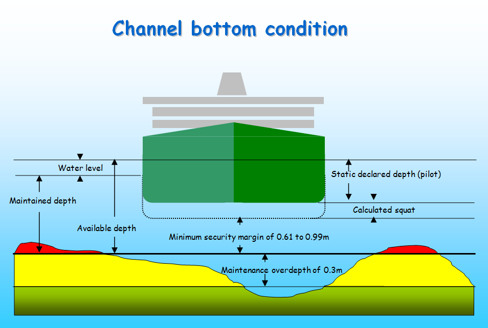
In actual fact, such dynamic information (which is updated on a day-to-day basis between Montreal and Ile aux Coudres) supplements nautical charts and official publications and is very useful to users. The RYG colour coding gives an overview of channel conditions depending on the current level of service being offered in the Saint Lawrence navigable waterways.
· Depth in red (R) shows shallower depths than the depth indicated on nautical charts (maintained depth or dredged area) thereby revealing shoaling for which a Notice to Shipping (NOTSHIP) was broadcast throughout our traditional communication channels and through the Internet from the MarInfo web site.
· Depth in yellow (Y), shows deeper depths than the depth indicated on nautical charts (maintained depth or dredged area) although they do not reach the 30-cm (minimum) overdepth allowance recommended by the Canadian Waterways National Manoeuvring Guidelines to account for imprecise measurement and waterway siltation. This means that within such waterway segments, mariners should give special attention to the current under-keel clearance management rules in force in the Saint Lawrence navigable waterway.

· Depth in green (G) shows deeper depths than the depth indicated on nautical charts (maintained depth or dredged area) including the 30-cm overdepth allowance recommended by the Canadian Waterways National Manoeuvring Guidelines in Canadian navigable Waterways.
Channel conditions are updated daily along the soundings carried out by the Canadian Hydrographic Services (CHS) and Public Services and Procurement Canada (PSPC) for the Coast Guard the day before, and are hereafter displayed in three versions;
· Channel conditions for the current year show an overview of work in progress at the time of the consultation;
· Channel conditions at the end of the previous year show a comprehensive view of area soundings collected annually;
· Coming soon, the historical conditions of the navigable waterway show views of occasional soundings of areas (deep water section of waterway soundings approximately once every five years).
All these different views of the waterway bring out the best overall information available on the channel conditions. However, it is to be noted that the accuracy of this information is time-sensitive and may vary depending on the age of the survey and the extent of the sedimentation in the affected area. User judgment is therefore required for interpreting these overall representations.
Report a problem on this page
- Date modified:


