
Ice Control Zones Status
JOINT INDUSTRY–GOVERNMENT GUIDELINES FOR THE CONTROL OF OIL TANKERS AND BULK CHEMICAL CARRIERS IN ICE CONTROL ZONES OF EASTERN CANADA
TP 15163
https://www.tc.gc.ca/eng/marinesafety/tp-tp15163-menu-4025.htm

Ice Control Zones


“T”  - Active North of 55N
“U”  - Not Active
“V”  - Not Active
“V 1”- Not Active
“W”  - Not Active
“X”  - Not Active
“X 1”- Not Active
“Y”  - Not Active
“Z”  - Not Active


Strait of Belle Isle is recommended for shipping as of 11 May, 2026


Updated 15 May, 2026
Eastern Canada Ice Control ZonesFootnote 1
Text version: Eastern Canada Ice Control Zones
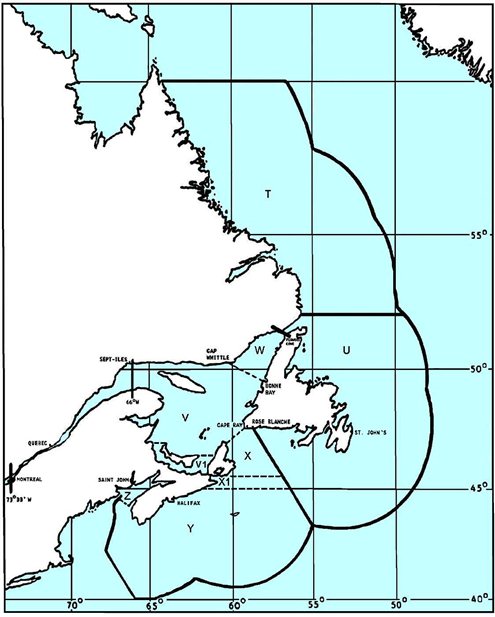
A map showing the limits of Transport Canada's Ice Control Zones within Canada's exclusive economic zone waters' limits. Broadly the zones are defined as follows:
- Zone T: From latitude 60 degrees North down to Strait of Belle Isle.
- Zone U: Belle Isle and Newfoundland surroundings from North to South is zone U.
- Zone V: Mostly the Gulf's core.
- Zone W: North East of the Gulf leading to Belle Isle.
- Zone X: Laurentian Channel, East of Cape Breton.
- Zone Y: South and South Eastern of Nova Scotia.
- Zone Z: Bay of Fundy.
- Zone V1: Northumberland Strait.
- Zone X1: Canso Causeway following 45 degrees North into the Laurentian Channel.
More details are available at Appendix A - Description of Ice Control Zones (canada.ca)
Report a problem on this page
- Date modified: